| | | | | | | | | |
| |
| |
| |
| |
| |
| |
| |
| |
| |
Hurricane Irene Update
Tuesday Aug. 23: All day the predictions were not too worrisome....then during the evening our premiere local
weatherman Skip Waters started to sound the alarm that Irene could be very troublesome.
Wednesday Aug. 24: Made arrangements to have the boat pulled (we don't have a trailer for our 28 ft. boat) and
took the short cruise to New Bern for the haul out. We have ridden out all the previous storms at our ten slip marina
which is nestled in a nicely protected cove.....but this storm looked like it had the potential to be huge.
Thursday: Working with our other boat owners to arrange for pulling their boats. Checked with BoatUS insurance to
confirm they pay 1/2 the costs of the haul out.....and opened a claim.
Friday am: the track keeps shifting.....but now it looks like we will have 90 mph sustained winds and gusts higher.
The storm surge is projected at 9ft....which means significant areas of Craven/Pamlico County will flood, but will pose
no problem for Baird Creek Point.
Friday afternoon: The boats at our ten slip marina are successfully stowed. Our friends at Baird Shores just across
the creek reiterated we are free to use their boat ramp whenever we would like to. The hurricane is now about 300
miles away heading directly for us.
I will post photos of Baird Creek Point as the storm progresses.
Tuesday afternoon:
Power was out from Saturday early am until just now (Tues afternoon)....as a result, there have been no
updates:
This turned out to be a huge storm even though it was "only" a category 1. The flooding exceeded those of the
famous Isabell several years ago....and the impact in NC was strongest in Pamlico County. We have some pictures,
but it will take a bit before I can transfer them from the Blackberry to this site.....in the meantime here is a summary:
All BCP property homesites remained high and dry....our rolling terrain worked perfectly and drained the rain water
and easily absorbed the water surge keeping the higher ground nicely dry.
Our ten slip marina was under water by about 4 feet at the peak....but all decking and piles are perfectly
intact.....thanks to our high density platforms. The electric outlets were submerged and we are waiting until they dry
out a little more to see if they will need replacement.
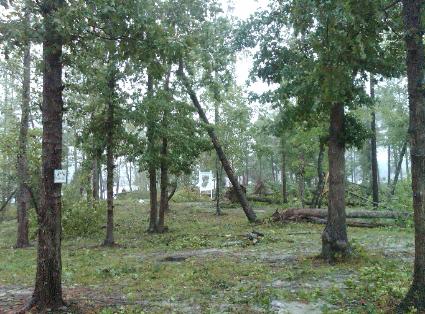
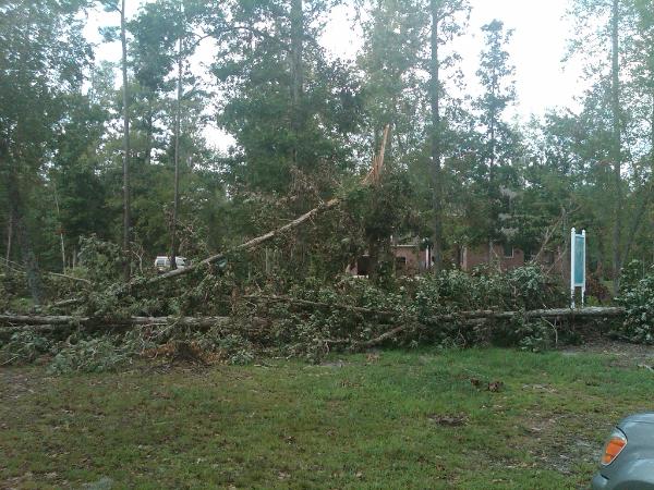
The storm culled several dozen trees....mostly hardwoods, fewer pines. Lot 1 and 2 had the most trees down: from the
look of it these lots there was some kind of "microburst" or small tornado judging from the concentrated impact. We
are talking to several timber companies to see about harvesting the fallen trees and maybe getting paid for the
material or at least covering the cost of cleanup. We will contact property owners to get permission to clean up their
lots and inform them of any possible prorated payment from the timber company.
Check back Wednesday for storm aftermath pics.
Click here to see the Oriental Harborcam.....use the pull down menu to see photos of
Hurricane Ophelia and Isabelle flooding in Oriental....provides an interesting
comparison to Irene's impact.
Tuesday Aug. 23: All day the predictions were not too worrisome....then during the evening our premiere local
weatherman Skip Waters started to sound the alarm that Irene could be very troublesome.
Wednesday Aug. 24: Made arrangements to have the boat pulled (we don't have a trailer for our 28 ft. boat) and
took the short cruise to New Bern for the haul out. We have ridden out all the previous storms at our ten slip marina
which is nestled in a nicely protected cove.....but this storm looked like it had the potential to be huge.
Thursday: Working with our other boat owners to arrange for pulling their boats. Checked with BoatUS insurance to
confirm they pay 1/2 the costs of the haul out.....and opened a claim.
Friday am: the track keeps shifting.....but now it looks like we will have 90 mph sustained winds and gusts higher.
The storm surge is projected at 9ft....which means significant areas of Craven/Pamlico County will flood, but will pose
no problem for Baird Creek Point.
Friday afternoon: The boats at our ten slip marina are successfully stowed. Our friends at Baird Shores just across
the creek reiterated we are free to use their boat ramp whenever we would like to. The hurricane is now about 300
miles away heading directly for us.
I will post photos of Baird Creek Point as the storm progresses.
Tuesday afternoon:
Power was out from Saturday early am until just now (Tues afternoon)....as a result, there have been no
updates:
This turned out to be a huge storm even though it was "only" a category 1. The flooding exceeded those of the
famous Isabell several years ago....and the impact in NC was strongest in Pamlico County. We have some pictures,
but it will take a bit before I can transfer them from the Blackberry to this site.....in the meantime here is a summary:
All BCP property homesites remained high and dry....our rolling terrain worked perfectly and drained the rain water
and easily absorbed the water surge keeping the higher ground nicely dry.
Our ten slip marina was under water by about 4 feet at the peak....but all decking and piles are perfectly
intact.....thanks to our high density platforms. The electric outlets were submerged and we are waiting until they dry
out a little more to see if they will need replacement.
The storm culled several dozen trees....mostly hardwoods, fewer pines. Lot 1 and 2 had the most trees down: from the
look of it these lots there was some kind of "microburst" or small tornado judging from the concentrated impact. We
are talking to several timber companies to see about harvesting the fallen trees and maybe getting paid for the
material or at least covering the cost of cleanup. We will contact property owners to get permission to clean up their
lots and inform them of any possible prorated payment from the timber company.
Check back Wednesday for storm aftermath pics.
Click here to see the Oriental Harborcam.....use the pull down menu to see photos of
Hurricane Ophelia and Isabelle flooding in Oriental....provides an interesting
comparison to Irene's impact.
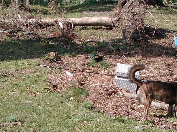
ABOVE: This is from Lot 2 "The Point"....this shows the high water mark which is below the
home site. The tool box floated up....probably from a neighbor on the other side of the
waterway which has lower elevation.
home site. The tool box floated up....probably from a neighbor on the other side of the
waterway which has lower elevation.
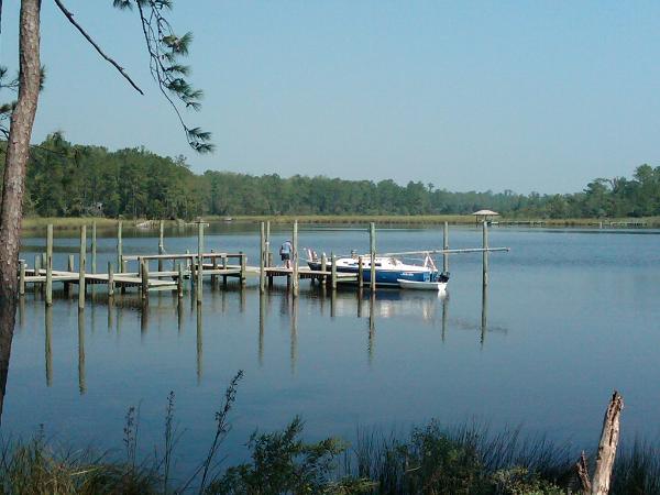
ABOVE: 25' sailboat returning to our ten slip marina. He anchored in Baird Creek to ride out
the storm and to minimize the risk of damage from contact with the dock structure. He double
the storm and to minimize the risk of damage from contact with the dock structure. He double
ABOVE: Trees down on Lot 2 "The Point" with Lot 14 in the background. The home on Lot 14
had one tree down near his dock walkway. The home stayed well above high water and
weathered the storm without a problem.
had one tree down near his dock walkway. The home stayed well above high water and
weathered the storm without a problem.